
EGSIEM aims at using gravity field analysis for forecasting and mapping of hydrological extremes like large-scale draughts and flood events. Observations of the redistribution of water and ice mass derived from the current GRACE mission, the future GRACE-FO mission and additional data are not part of the inventory of EO data products to date, although they constitute a new and unique remote sensing opportunity with innovative approaches to flood and drought monitoring and forecasting. Traditional earth observation resources for monitoring large scale disasters and disaster response based on weather satellites or optical and SAR satellites are provided by mechanisms and services such as the International Charter, the European Copernicus Emergency Management Service or Sentinel Asia, for example. This year the International Charter "Space and Major Disasters“ celebrates its 15th anniversary.
The International Charter is an international consortium of space agencies which provide a unified system of space data acquisition and delivery to those affected by natural or man-made disasters through Authorized Users. Each agency member has committed resources to support the provisions of the Charter and thus is helping to mitigate the effects of disasters on human life and property. The Charter was initiated by the European Space Agency ESA and the French Space Agency CNES at the UNISPACE III Conference in Vienna in 1999. After the Canadian Space Agency CSA joined shortly after, the Charter declared operational as of November 1, 2000 after formal rehearsals and qualification tests. Since then, the consortium grew up to 15 partners distributed all over the globe, such as the space agencies from Argentina (CONAE), Brazil (INPE), China (CNSA), Germany (DLR), India (ISRO), Japan (JAXA), Russia (ROSCOSMOS) South Korea (KARI) and the United Kingdom (UKSA), as well as the European Organisation for the Exploitation of Meteorological Satellites (EUMETSAT) and the United States authorities National Oceanic and Atmospheric Administration (NOAA) and United States Geological Survey (USGS). To date the Charter was activated for 465 disasters in over 110 countries worldwide. More than 50 per cent of all disasters have been floods (including Tsunamis), followed by ocean storms (15 %), earthquakes (11 %), Fires (7 %), Volcanoes (6 %) and other disasters.
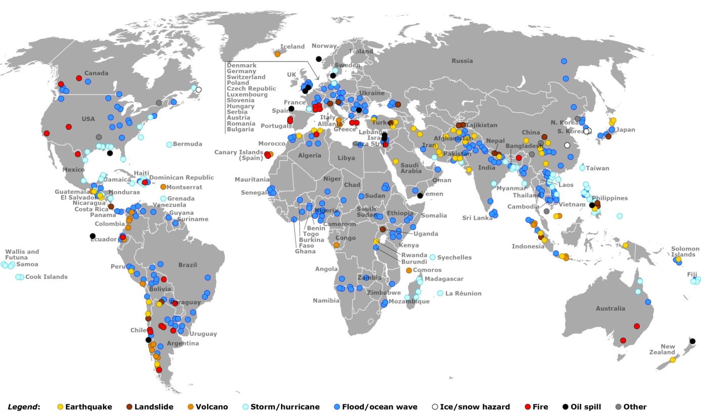
The map above shows the distribution of Charter activations worldwide from 2000-2014 according to disaster types.
For further information please visit the Charter website