
As mentioned before, both GNSS and Hydrology time series will be used for validation within the EGSIEM project. During the last months, we have already set up part of the GNSS and Hydrology processing on our server.
For the GNSS part, we have finished the automatic pre-processing of the latest existing global daily GPS time series from JPL and SOPAC (ftp://garner.ucsd.edu/pub/timeseries/measures/ats/Global). We use the global cleaned and detrended daily time series, among which the mean, trend, coseismic and seismic jumps (including offset and deday) are already removed. The outlier has already been removed using analyze_tseri, so we don't need to do outlier detection here. These two kinds of GPS daily time series are then averaged into weekly data for later combination with the Hydrology and GRACE model. After we obtain the BERN provided GPS time series, we'll then set up its own processing according to the requirement of the input data, considering offset, outlier detection, etc.
For the Hydrology part, our recent focus is the conversion of WGHM model into surface displacement. In particular, GFZ has provided us with three versions of WGHM model, namely WGHM_2.1f6, which is available for the longest GRACE period, until 12/2013, but with output of monthly resolution only, the WGHM_2.2_STANDARD, the latest official version, with daily output until 12/2010, and the WGHM_2.2_STANDARD_CRU, a modification of the latter, using different climate forcing that allowed us to extent the simulation period until 12/2012. This version, however, is not calibrated for this particular climate input. For testing purposes, we include all these three WGHM models in our validation process so as to investigate how much the model difference is. Until now, we have finished the conversion from these three monthly WGHM model into displacement time series for the above JPL/SOPAC IGS stations. The processing for daily WGHM conversion will be set up later. The obtained WGHM displacement time series are then detrended and interpolated into weekly values for GNSS combination.
Table 1 shows parts the height WRMS results of the above three WGHM models for both JPL and SOPAC datasets. For comparison, we also put the GLDAS results here. Since the WGHM_2.2STANDARD ends until 12/2010, we restrict the analysis between 2002 (GRACE launch year) and 2010 here.
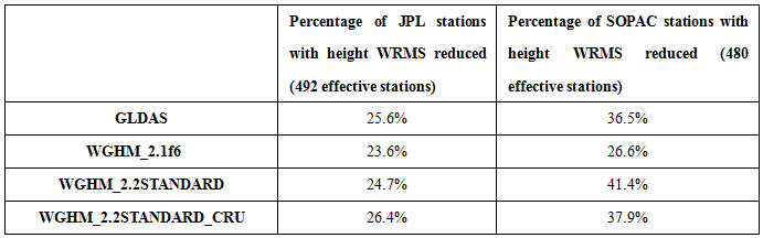
From the above very preliminary processing, we find that GPS dataset plays a very important role when comparing GPS with hydrology loading models. Generally, the SOPAC time series seems to be better than the JPL for validation here. Further detailed investigation is still needed to find out the reason. It also gives us a hint to search for more GNSS datasets to prove the reliability of our final GPS validation data.
For the hydrology model, our analysis proves the advantage of the WGHM version 2.2 model with respect to the GLDAS model. We think that one of the reasons may due to the included groundwater, surface water in rivers, lakes, reservoirs and wetlands in the WGHM model. After detailed comparative analysis with different water components, we’ll find out the answer. With respect to the SOPAC dataset, it seems that both the WGHM version 2.2 models perform much better than the version 2.1 in reducing the WRMS of the global GPS height. However, the improved WGHM_2.2STANDARD_CRU seems only performs better than the WGHM_2.2STANDARD model in correcting the JPL height. The problem may be caused by the different stations used in the JPL and SOPAC datasets. In our later validation process, we have to improve our system to restrict all our analysis to the same GPS stations.