
In figure 1 the typical rapid mapping workflow of ZKI during crisis situations is illustrated. After the disaster the initial mobilisation phase follows. Civil protection offices, situation centers or decision makers receive information regarding the occurrence of a crisis event and trigger ZKI activities either directly or indirectly through authorised users.
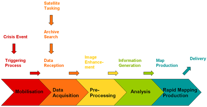
Figure 1: Rapid Mapping Workflow - from crisis events to the delivery of information
ZKI starts directly its activities by tasking earth observation satellites that may provide relevant crisis data. In addition, the data archive is searched for matching pre-disaster satellite scenes. During the first 6 hours after the activation of ZKI, reference maps based on archive satellite data providing a first overview of the affected area can be made available to relief organisations. The newly acquired post-disaster satellite data is used to assess and monitor the ongoing crisis situation, i.e. delineate the affected areas and estimate the damages caused by the disaster.
The operational rapid mapping concept shall be enhanced by the integration of an early warning component based on gravity based indicators for flood forecasting and drought monitoring which are outcomes of the EGSIEM Hydrological Service. Requirements expressed by the users of satellite rapid mapping products focus on timely and high frequency flood monitoring from the onset of a flood event, with a special focus on mapping the flood extent at peak level, until water levels have receded to near normal stages. For this task a number of SAR and optical satellites have to be tasked, as it is done within mechanisms such as the International Charter or the European Copernicus Emergency Management Service. Both mechanisms are activated upon user requests which mean that satellite tasking does not start before a user request has been received. In some cases, i.e. when a large flood evolves quickly or has not been considered as evolving into a major flood event, user request came in relatively late and satellite tasking could not be put into effect until flood peak had already passed the area. For such cases a proactive satellite tasking based on external information such as gravity based indicators would have been desirable. In order to enhance the rapid mapping service with such indicators operational workflows for improved on demand programming of high and medium resolution satellite data shall be developed and evaluated, as shown in figure 2. This will be implemented during the last year of the project.
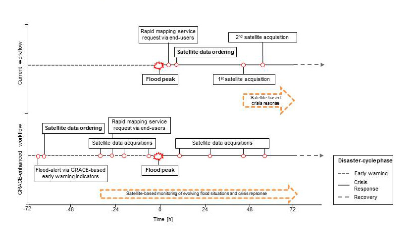
Figure 2: Improved satellite tasking by using GRACE measurements as flood early warning indicators